El Oculto
El Oculto (High sulphidation subvolcanic: epithermal Au/Ag) Summary of Highlights by Dr. T.A. Richards and Ron Bilquist January, 2003 (with 2009 update)
Geology and Setting
The Oculto property is one of a number of high sulphidation, epithermal precious metal showings located along the axis of a major extensional job in the Olacapato segment of the Calama-Olacapato-El Toro transverse zone. It is hosted in clay-silica-alunite alteration associated with the emplacement of Miocene biotite-feldspar porphyry dykes, sills and plugs intrusive into red-bed sediments of the Cretaceous Salta Group.
Previous work interpreted the prospect as a porphyry setting. . Limited and shallow Reverse Circulation drilling was targeted based on the porphyry geological model assumption.
Of 84 prospecting samples taken in 2009 by Salta Expl throughout the property, 25 assayed >30 g/t silver and 14 were +100 g/t. Sampling from grassroots prospecting outlined a 200 metre zone of highly anomalous gold and silver mineralization hosted in altered red-bed sediments adjacent to altered porphyry intrusive. Of 21 samples taken across this zone, 9 were greater than 1000 ppb gold (high of 6.9 g/t) and 8 were greater than 100 g/t silver (highs of 597, 797 and 5,447 g/t 175 oz/t silver). Alteration and mineralization appears strongest developed within permeable sedimentary units, dominantly sandstone and conglomerate and moderate to weakly developed in mudstone. RC drilling on the showing area was collared in red-bed mudstone.
Much of the Oculto property is untested in regard to its high-sulphidation epithermal potential. It is underlain by km-scale alteration zones hosted by high-level intrusions and the permeable facies of the Salta Group, which is the mostly untested for gold and silver potential.
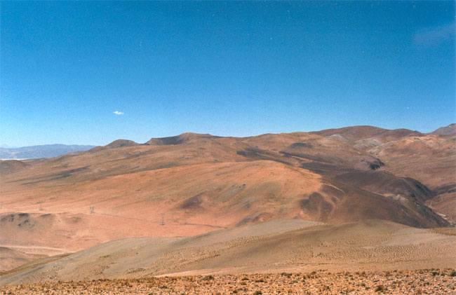
In the cover photo, the El Oculto showings are on the horizon near the center of the photo. The bleached sandstones and conglomerates can be seen at the right side of the photo near the center. The AMD showing is off the photo to the right. The powerline can be seen in the lower left of the photo.
The AMD ground adjoins and lies between the El Oculto showings on the west and a gold property Aguas Calientes on the east. A prospector described the geology as bleached red-bed sediments of sandstone to pebble conglomerates. Fifteen samples were taken from an area 25 by 35 metres in a silica altered pebble conglomerate. Seven of these ranged between 229 g/t g/t and 1331g/t g/t silver with five greater than 500 g/t silver (42.8 oz/t) g/t. Gold values were also elevated with values between 0.321 g/t and 2.210 g/t (five >1.0 ppb). Very limited prospecting has been carried out in the area of this new discovery. It represents one of the numerous mineralized systems hosted in altered red-bed sediments and Miocene intrusions along extensional jogs in the western part of the Olacapato transverse zone.
Status
Cascadero Minerals S.A. is the registered owner of 100% of El Oculto. Tom Richards and Ron Bilquist January 2003
December 2009 Update
In early December Les Allen and I visited the Oculto property for one day. Our purpose was to try and locate three areas that we knew about within Oculto property that are anomalous in gold and silver. Our intent was to determine the extent of alteration/mineralized areas as well as the trend. Since there had been a fairly extensive work program in the past by a Vancouver based junior company we also wanted to see again where this work was carried out in relation to the known gold/silver zones. For simplicity, on the attached photos and image I have referred to the zones as A, B and C zones.
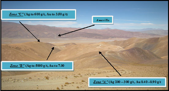
The Au/Ag Zones at Olculto (view westerly)
Prospecting: In regards to the Oculto property, we found that the three zones are more or less similar in that the gold and silver mineralization appears to be hosted in argillic altered volcanics (possible tuffs or ignimbrites) as well as argillic altered basin sediments. Stockworks of a brown siliceous material are what appears to be the setting in which the gold and silver occur and this is likely what previous prospectors focused on.
Prior exploration seemed to focus more to the south and away from the gold and silver alteration zones. There soil geochem survey just touches on "Zone B" and "Zone C" but we don't know what elements were analyzed the samples for and also the price of silver was likely low at the time of their work. I will refer to the drilling when I discuss "Zone B".
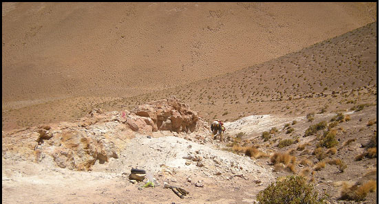
At "Zone A" the area of stockworks and alteration is about 60 metres or more wide. The veining is typical stock work with the smaller veins and veinlets appearing to go all directions with the larger, stronger veins having a trend of about 70 degrees and were traced for more than 100 metres along trend into overburden cover. The outcrops are on a small knoll along an old drill access road although no drilling or other exploration appears to have been done at this location. This showing appears to be hosted in the argillic altered volcanics as the rocks to the on north and south, are a fresh variety of what we assume is the host of the mineralization. Between us we took eight samples at this location.
Zone "B" is fairly interesting as it is hosted in the younger basin sediments and is flanked by two RC drill holes. The zone again is stock work of the chocolate colored 'silica' as well as veins of greenish-yellow coated blue quartz with disseminated pyrite and a silver grey mineral (silver arsenate?). There are a number of old pits in this area. Eight samples were taken from this area. The RC drilling would have missed this gold/silver target as the hole up slope to the south east was oriented to parallel the zone. The drill hole on the north west was aimed at the zone but was set too far back to intercept. The area of alteration, stock work and veins is about 100 metres wide and the strongest veins, and likely the entire alteration system, seems to trend about 60 degrees with a very steep 85 degree dip to the south. Zone "B" could be the westerly extension of Zone "A" which would give a continuation of more than one kilometre.
Zone "C" -- This zone is located on a knoll above and to the south about 100 to 200 metres of the Zone "A" to Zone "B" trend of mineralization and alteration. Exposure is poor here but the area hosting the mineralization appears to be similar to Zone "A" with stock work and veins cutting argillic altered volcanics. Outcrops and float are 'patchy' and due to overburden it is hard to determine a trend. Only two samples were taken at this location.
Conclusions and Recommendations:
El Oculto is a large claim block of 1,800 hectares and it appears that there are at least three strong mineralized zones are present Oculto property. The property is mostly overburden cover and rock samples from the out cropping areas usually produce a silver and gold assay. Previous work appeared to focus on a copper porphyry style of deposit and the gold and silver was likely ignored. It is possible that a deeper porphyry system may be present with the epithermal system that is partially exposed may be telescoped above the porphyry. None off the RC drill holes was deep enough to test this hypothesis.
The zones looked at this time appear to trend roughly 60 to 70 degrees and are more or less in line (Zone "C" slightly offset to the south) on this trend.
Considering the space between the known occurrences it is highly possible that there are yet undiscovered zones of gold and silver mineralization on this property.
Access to the property is excellent with a network of roads already in place. The property lies just inside Jujuy and is proximal to an active railroad as well as the small towns of Olacapato on the west. Water for drilling could be obtained from the stream that flows from the Tocomar hot springs.